


In today’s world, what you don’t know can hurt you. If your organization doesn’t have the software tools needed to accurately visualize, analyze, and use data inputs, your entire team isn’t set up for success.
But with the right resources, support, and expertise at your disposal, you can make an even bigger impact and achieve your mission with confidence.
Axim Geospatial provides the cutting-edge platforms you need to make better decisions, reduce risk, save money, and put your data to good use.

How much stress could your organization avoid if you could access data and project metrics easily, when and where you need them?
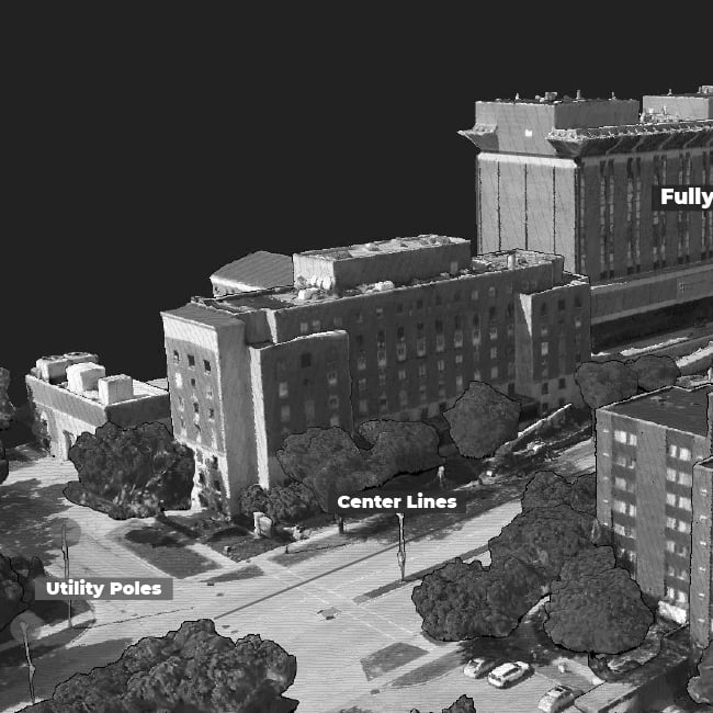
TheGeoAnalyst is a web-based platform for geospatial data visualization that uses 3D lidar point clouds, 360 degree imagery, asset attribution, and vector data to instantly access cloud-hosted data through mobile and desktop web-based platforms.
In addition to providing real-time portal visibility for dashboards and maps, it provides you with actionable data to help you understand your project status and quickly respond to issues. It also doesn’t require proprietary software, reducing the burden on IT resources.
As expert geospatial solution developers, Axim takes the time to understand your needs and builds products to meet those needs. We have developed hundreds of dashboards and portals using various data streams, including TheGeoAnalyst.
If TheGeoAnalyst could make data analysis and project tracking easier for your team, schedule a meeting with Axim today. Together, we will ensure you can conveniently access the necessary data so users can understand and take action.
Having spatially accurate geospatial data is one thing. Understanding its fitness-for-use and quality related to a particular use case is another challenge altogether. With Data Fitness, you can assign quality scores to geospatial data sets and relate those scores to different use cases to make fast decisions on whether a geospatial data set will meet your needs.
Data Fitness leverages machine learning algorithms to identify how complete and accurate a data set is based on the variables and criticality you determine. Quality is a result of expert geospatial technicians, as well as leveraging custom tools to improve and qualify a quality deliverable.
The Axim team has helped organizations optimize their data for 30 years. Using Data Fitness, we can help you better organize, understand, and utilize your data sets—while simultaneously reducing headaches for your team members in the process.


In order to keep the people you serve and your employees safe, you need a centralized and consistent way to view information related to their security preparedness, response, posture, readiness, and risk.
We provide situational awareness for security and emergency response personnel using ARTiY (Awareness, Response, Training, Intelligence, & Your Security), a geospatial facility situational awareness solution that helps organizations:
Ideal for organizations with numerous facilities that are geographically dispersed, ARTiY can help you meet requirements for anti-terrorism and physical security, including requirements for digital floorplans, records of trainings, drill tracking, and facility force protection assessments. It also saves your organization time that would otherwise be spent searching for facility information.
Additionally, ARTiY gives security and emergency response personnel a geospatial solution for crisis management, incident planning, and security posture visualization. This is accomplished by 2D and 3D environments for 360-degree interactive walkthroughs, critical asset inventory, floorplans, and collaboration using sensor networks.
If protecting your community, your clients, or your employees is your top priority, schedule a meeting today to put a solution like ARTiY to work for your organization.
Requiring inspectors to travel from site to site to perform inspections can be a hassle. With SiteScene, you can provide remote access for site inspections and review, from the comfort of your office.
SiteScene is a cloud-based software that provides secure review of on site conditions using high definition video, imagery, and detailed asset information. SiteScene leverages HD video and imagery to provide clear and direct views and context about a site’s condition.
SiteScene has been in use for years at many critical infrastructure sites. In addition to saving you time and headaches, the software allows you to:
The Axim team is an expert in collecting and displaying high-resolution video and imagery. We have helped dozens of organizations use SiteScene to display critical data in meaningful ways, and we would be honored to help your organization as well.
In many instances, you need to share your data with a third party to move forward with a project. But strict privacy regulations and compliance requirements can make this task a challenge. This is especially the case for the medical industry, private security firms, or businesses that collect confidential financial data.
Fortunately, using MapMasq, you can still make the best decisions by seeing clusters of data overall in an area. MapMasq is a collection of tools that use geo-masking to anonymize geospatial data. Simply put, geo-masking alters the coordinate location of zero-point data, protecting the sensitive or private information associated with that point data.
MapMasq provides a displacement distortion through a statistical distribution that you can control. Whether you are collecting data of urban areas, individuals, or large sectors of the country, you can feel confident knowing that you are taking every precaution to keep your data safe.
Don’t let privacy concerns prevent you from taking action. Schedule a meeting with Axim today, and let’s work together to ensure you have the resources you need to stick to your timelines.
Obtaining accurate, actionable data doesn’t have to be a headache. Request a demo for one of the products above, and our team will get to know your mission, walk you through your options, and help you identify simple ways your team can work smarter (not harder).

