This article may reference work, projects, customers, and contracts related to NV5 legacy companies before their acquisition by NV5.
In an ever-changing worldwide social and political landscape, military and intelligence organizations face increasing challenges in obtaining accurate and up-to-date information to make informed decisions and stay ahead of the curve. Access to advancing open-source based technologies continue to increase adversarial capabilities, requiring a fresh approach to traditional analysis which incorporates a faster perspective that is highly adaptable and accessible to a broader audience.
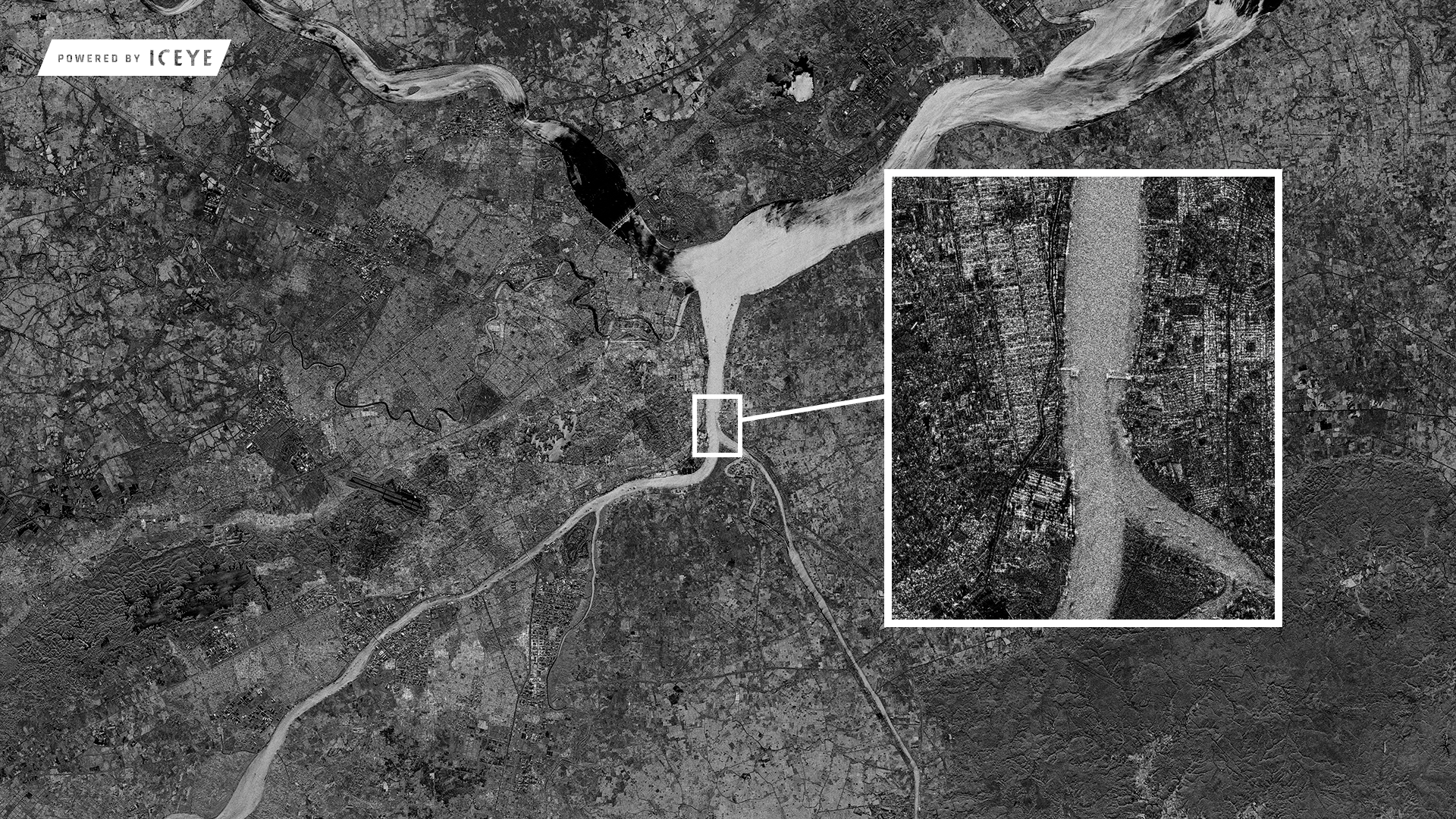
Fortunately, with the emergence of both commercial and publicly-available Synthetic Aperture Radar (SAR) into Geospatial Intelligence (GEOINT), military and intelligence organizations can now gather medium to high-resolution data of the Earth's surface, even in challenging conditions like darkness or cloud cover. These technologies have become a game-changer, providing valuable insights for improved intelligence analysis, situational awareness, and strategic planning.
Combining these GEOINT technologies with Open-Source Intelligence (OSINT) is also a valuable discipline for collecting and analyzing publicly available information to quickly support operations and decision-making. The implementation of commercial and publicly-available SAR into GEOINT and OSINT is revolutionizing the way military and intelligence organizations operate, providing a faster and more comprehensive approach to intelligence gathering and analysis.
Medium to High-Resolution SAR in Challenging Conditions
Different from typical electro-optical (EO) sensors, SAR uses radar waves that have the ability to penetrate through cloud cover and gather information without the need for illumination. This unique capability allows military and intelligence organizations to obtain medium to high-resolution SAR (depending on the asset) of the Earth's surface at any time of day or night, providing critical information for accurate decision-making.
Although SAR technology has been used by military and intelligence organizations for some time, its increasing availability as commercial and publicly-available data has made it more prevalent and accessible. This makes SAR a valuable tool in today's fast-paced and data-driven environment, enabling military and intelligence organizations to effectively gather crucial information in challenging conditions that may have otherwise hindered their operations.
For example, NV5's SAR Analysts employed the advanced capabilities of SAR technology, specifically using the commercially available ICEYE SAR, to analyze aircraft concealed beneath a lite-structure (e.g., thin, temporary, or hanger) at Foshan Airport, China. As SAR emits radar waves, they interact with surfaces and objects, reflecting off the aircraft hidden beneath the lite-structure and returning to the SAR sensor. By measuring the time delay and phase shift of the returning signal, and ensuring an optimal look angle, the SAR system can return detailed data of the concealed aircraft. This unique ability to penetrate open or porous surfaces and analyze the reflections from the underlying objects allowed NV5's analysts to gain valuable insights into the aircraft at Foshan Airport, despite their concealment.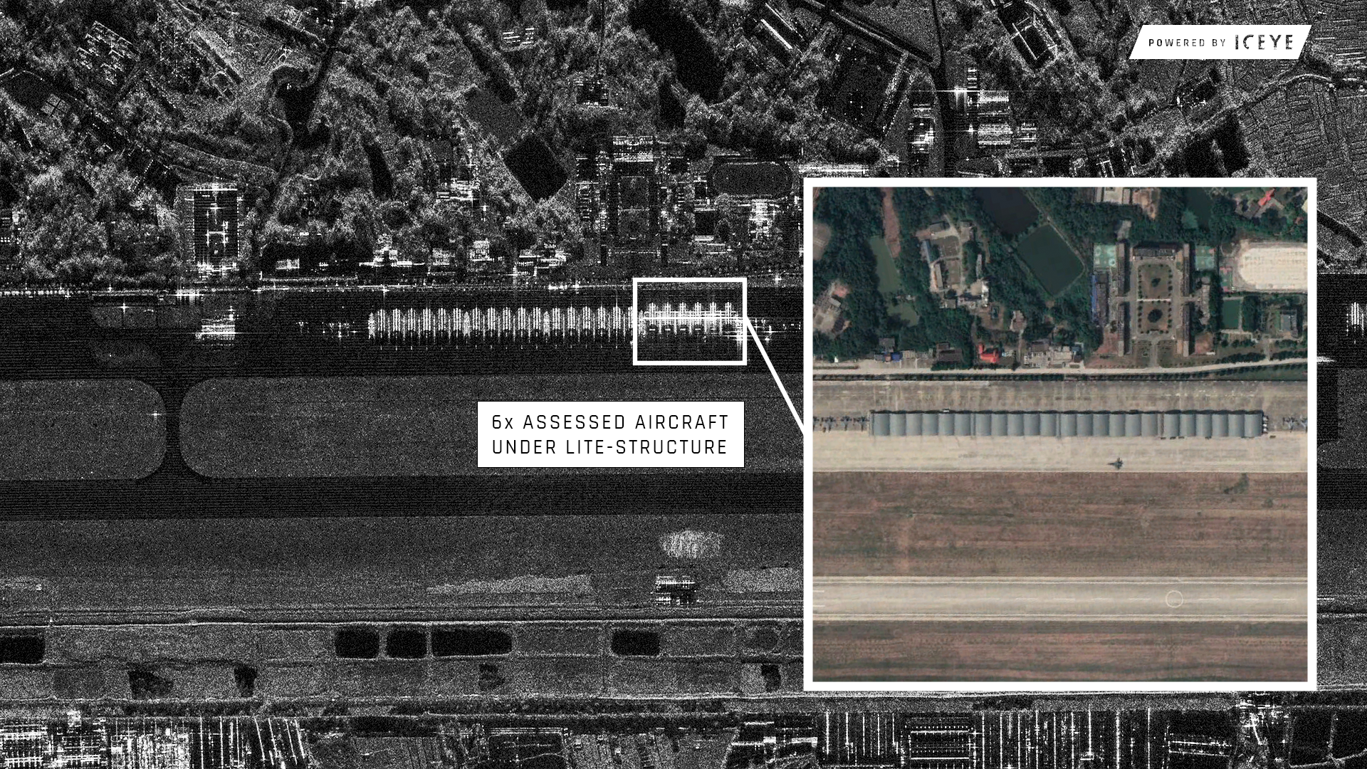
SAR's ability to provide detailed data of the Earth's surface in any weather condition and even into some lite-structures offers a significant advantage to decision-makers in the field, enabling them to make informed decisions with confidence.
Persistent-Monitoring for Improved Situational Awareness
Unlike traditional EO, which can be limited by cloud cover or darkness, SAR gathers information regardless of weather or illumination. Through persistent-monitoring SAR can identify new targets, track movement, detect objects, or even assess the impact of natural disasters on critical infrastructure. For example, NV5’s SAR Analysts were able to use red and blue false-color analysis on commercially available ICEYE SAR to identify change in activity of Blackhawk helicopters.
The wealth of information provided by SAR supports a wide range of analysis, including target identification, situational awareness, and strategic planning. SAR provides military and intelligence organizations with a comprehensive understanding of the operational environment, helping them stay ahead of potential threats and make critical decisions with increased confidence.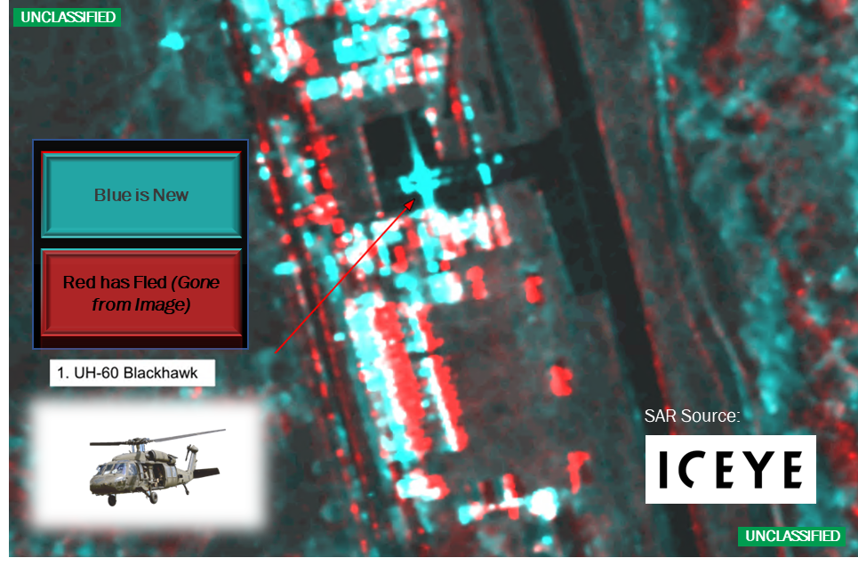
Utilizing Computer Vision and Machine Learning in SAR Analysis
The combination of computer vision and machine learning is transforming the way military and intelligence organizations analyze SAR data. Advances in these fields have led to the development of more accurate SAR algorithms, which are increasingly available commercially. This has increased the popularity of SAR in the field of computer vision. The improved accuracy of these algorithms allows for quicker and more precise identification and classification of objects such as aircraft, vessels, and vehicles, providing valuable information for intelligence analysis. These techniques can also be used to monitor changes in the environment, including deforestation and infrastructure expansion, supporting a wide range of analysis. While obtaining high-quality training data can still be a challenge, the growing availability of public and commercial training data and algorithms is making it more accessible and affordable for a wider range of organizations. The integration of computer vision and machine learning in SAR analysis offers exciting opportunities for enhanced GEOINT analysis and situational awareness.
Multi-Source Data Fusion with SAR and GIS
GIS can be used to integrate SAR with other data sources, such as maps, EO imagery, terrain data, and weather patterns. This multi-source data fusion can provide a more comprehensive picture of the operational environment, supporting improved intelligence analysis and situational awareness. By using multiple sources of data, cross-validation and confirmation of findings can be achieved, reducing the risk of errors, and improving the accuracy of intelligence analysis. Furthermore, multi-source data fusion enables predictive modeling, which can support proactive decision-making and planning. The combination of SAR, GIS, and computer vision offers unparalleled opportunities for military and intelligence organizations to gain valuable insights and make informed decisions.
Increased Accessibility and Affordability of SAR
The growth of SAR technologies and the increasing availability of publicly-available and commercial data have made SAR more accessible and affordable for a wider range of organizations, including military and intelligence, academia, and the private sector. This is largely due to the rise in commercial and publicly launched satellites and sensors specifically dedicated to SAR, reducing the reliance on private-access-only options.
One important benefit of increased accessibility and affordability of SAR is its application in disaster relief efforts. For example, publicly-available and commercial SAR data has played a critical role in providing crucial information in the aftermath of natural disasters, such as Hurricane Katrina or the earthquake in Haiti. The data captured by SAR can help with search and rescue efforts by revealing the extent of damage to buildings and infrastructure. SAR data can also aid in the delivery of humanitarian aid by providing insight into the impacted area and the needs of the local population, or disaster response tools that can help first responders quickly assess damage and respond appropriately.
In addition to its impact in disaster relief, increased accessibility and affordability of SAR is also having a positive effect on conservation efforts. For instance, SAR data has been used to monitor deforestation and illegal mining activities in the Amazon rainforest, providing valuable information for conservationists and government agencies to take action.
To include military specific use of SAR we can look to Operation Inherent Resolve in Iraq and Syria where SAR was used by the US military to monitor the movement of enemy forces and assess the condition of key infrastructure such as oil refineries and transportation routes.
Furthermore, the availability of SAR data is facilitating research in fields such as ecology, geology, and agriculture, and enabling startups to develop new products and services that leverage SAR data. As an example, in agriculture, SAR data is utilized to develop crop monitoring tools that can help farmers increase yields and reduce waste.
The wide range of organizations and applications that can benefit from publicly-available and commercial SAR further highlights its importance and potential. This increased accessibility and affordability of SAR is a significant development in the field and offers unprecedented opportunities for organizations to gather valuable insights and make informed decisions.
The Exciting Future of Publicly-available and Commercial SAR
Publicly-available and commercial SAR offers a promising future, with the potential for significant advancements especially in military and intelligence operations, as well as in humanitarian and disaster relief efforts. Recent developments and applications of SAR technologies, including quantum radar, full polarimetric SAR, wide-area SAR, and SAR interferometry with multiple apertures, not only improve the precision but also enhance the details of the Earth's surface. This enables accurate mapping and monitoring of environmental changes. Furthermore, the integration of SAR data with artificial intelligence and other data sources, such as social media and weather information, can facilitate automated data processing and analysis, providing faster and more accurate information. These advancements demonstrate the exciting future of publicly-available and commercial SAR and its potential to revolutionize intelligence analysis and decision making.
Join the Revolution with NV5
At NV5, we are committed to being at the forefront of innovation in the realm of SAR analysis for military and intelligence operations. Stay connected with us to remain updated on the latest breakthroughs in this dynamic and rapidly evolving field.