This article may reference work, projects, customers, and contracts related to NV5 legacy companies before their acquisition by NV5.
Demystifying Graph Databases & GIS Through ArcGIS Knowledge
In the rapidly expanding world of GIS, a new player is disrupting the field and paving a transformative path forward - graph databases. If you're unfamiliar with this term, don't fret; you're about to discover how this innovative technology is revolutionizing the GIS landscape.
To grasp the basics, a graph database is a system where nodes (data points), edges (connections), and properties (attributes) interplay to map intricate networks of data relationships. Think of it as doodling on a whiteboard, tracing connections between entities minus the geographic coordinates. For instance, imagine charting the programming skills across a tech company's workforce. This web of connections would look like a detailed and interconnected graph.
Discovering the Power of ArcGIS Knowledge
ArcGIS Knowledge, an avant-garde tool, is transforming the GIS landscape by expanding how we construct, analyze, and understand intricate networks of information. It allows users to create investigations and use knowledge graphs that encapsulate entities - be they objects, concepts, or events - and the relationships between them.
The remarkable aspect of ArcGIS Knowledge lies in its ability to integrate seamlessly with existing GIS platforms like ArcGIS Pro, ArcGIS Enterprise, and ArcGIS Online. It also smoothly links with NoSQL databases like Neo4j, delivering profound data analysis and effective data management, all within the familiar user interface we GIS users know and appreciate. In addition, it supports Cypher queries, offering users an added flexibility in handling graph data.
At its core, ArcGIS Knowledge excels in representing data. Entities stand for specific items in the knowledge graph, and relationships outline the links between these entities. Together, these elements weave a rich tapestry of interconnected data, unveiling hidden patterns, trends, and insights. The tool is indeed a game-changer, taking the GIS familiarity we're accustomed to and amplifying it by plugging in seamlessly to deliver deeper, interconnected insights.
Transforming Real-World Scenarios: Conflict Armament Research Case Study
The power of graph databases becomes evident when we delve into practical applications, specifically where intricate connections between data points are paramount. Let's spotlight an organization leveraging this technology for a cause of global significance - Conflict Armament Research (CAR).
CAR —an independent, field-based, investigative organization— unravels the convoluted web of arms trafficking into areas of conflict. Traditionally, analysts would rely on tools like ArcGIS Pro to map out the tangled supply chains of weapons, as well the producers, dealers, and shippers behind their movement across multiple countries often over decades. However, by integrating ArcGIS Knowledge with graph databases, the analysis catapults to a whole new level.
By visualizing complex relationships between entities such as companies, armed groups, security forces, locations, items, and events, the analysts can unravel a more comprehensive picture of arms trafficking.
For instance, consider small-caliber ammunition, typically discharged by weapons like assault rifles and pistols.
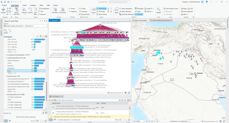
With ArcGIS Knowledge the analysts can sift through vast datasets and filter items related to small-caliber ammunition, kick-starting their investigative journey. ArcGIS Knowledge provides a dual perspective – a spatial view of ammunition locations and a link chart revealing underlying connections, such as ammunition flow and its end-users.
On the right, there is a map created from the investigation's search and filter results related to small arms ammunition. This showcases a familiar spatial representation of the data, with ammunition documentation sites mapped out across Iraq and north-east Syria. On the left side, there is also a link chart in a hierarchical layout, which aids in understanding the relationships that underpin the data. The capability also exists to search within these results and utilize the dynamic view. This interactive feature allows for entities on the map or link chart to be selected, with the data responding in real-time. As entities are chosen on the map or link chart, they are simultaneously highlighted on both, ensuring a seamless cross-referencing experience with the search and filter function. The investigation goes beyond spatial representation alone to uncover the role small arms caliber ammunition plays in the surrounding area and its movement, whether involving armed groups, brokers, or national security forces. Insights into ammunition dates, quantities, and much more can be obtained. CAR’s field investigation teams collect data to the ground to a highly granular level, enabling a depth of analysis which is only brought to light by the power of ArcGIS Knowledge.
The ability to visualize and interrogate data in this manner paints a more holistic picture, revealing hidden patterns and nuances that go beyond the purely geospatial. Coupling GIS with graph database analysis via ArcGIS Knowledge takes intelligence analysis into a new realm of capability, enhancing our understanding of global conflicts.
Analyzing Airspace Incursions with ArcGIS Knowledge
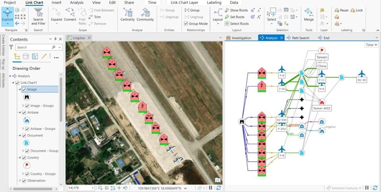
ArcGIS Knowledge plays a vital role in making sense of complex datasets in international defense and security scenarios. Here we have an instance of China's airspace incursions into Taiwan's Air Defense Identification Zone (ADIZ). The system can manage vast amounts of data and extract critical information.
In this scenario, a sudden surge in Chinese aircraft, including the KJ-500 early warning aircraft, entering the ADIZ was noted. Through its robust data analysis capabilities, ArcGIS Knowledge provided a detailed understanding of this significant geopolitical event.
The illustrative screenshot included here offers a clear picture - the physical locations of aircraft with the detections over imagery on the left as well as an interconnected link chart on the right, and any anomalies detected. Such an arrangement enables analysts to discern patterns or shared attributes between different aircraft or entities, paving the way for more nuanced insights and understanding.
As a comprehensive solution, ArcGIS Knowledge permits real-time data storage and distribution through various applications, making the analysis process even more efficient. This practical application, in the context of military operations, demonstrates the transformative potential of integrating graph databases with ArcGIS Knowledge.
Diving Deeper: Other Applications of Graph Databases
The transformative potential of graph databases in conjunction with ArcGIS Knowledge isn't limited to arms trafficking or military operations. Let's delve into other compelling use cases where this combination is truly transformative.
International Relations
Consider the realm of international relations. In this field, each country can be visualized as a node in the graph database, with various edges symbolizing different types of relationships—these could be trade agreements, historical conflicts, cultural ties, or even diplomatic treaties. By visualizing these intricate relationships, analysts can identify patterns, predict potential shifts in alliances or conflicts, and gain a holistic understanding of the complex landscape of global politics. These applications shift your team’s analysis from a reactive mindset to a proactive mindset to become predictive based on existing data correlations.
The intuitive and visual nature of graph databases is not just beneficial but indeed transformative in revealing the hidden nuances in international relations. This kind of analysis can lead to more accurate predictions and informed decision-making on a geopolitical scale.
Urban Planning & Infrastructure Development
When it comes to urban planning and infrastructure development, graph databases truly shine. Such projects often involve a multitude of interconnected elements—land parcels, infrastructure, public amenities, zoning laws, environmental regulations, and more. With the ability to visualize and analyze the complex network of relationships among these components, urban planners can effectively anticipate how a change in one area, such as a new zoning law or the construction of a highway, might impact surrounding communities and infrastructures.
Conclusion: Harnessing the Power of Graph Databases
In summary, graph databases are a game-changer in the field of GIS, offering unprecedented depth of analysis and insight. By focusing equally on data points and their interconnections, they illustrate and dissect complex relationships on a grand scale. When integrated with platforms like ArcGIS Knowledge, graph databases have the potential to revolutionize our approach to large-scale data analysis and decision-making.
Whether you're navigating the intricate network of international diplomacy, shaping the future cities, or delving into the web of arms trafficking, graph databases open new realms of understanding and insight. They unveil the patterns hidden in the intricate tapestry of data, empowering us to anticipate changes, make informed decisions, and work towards a better, safer world.
So, if you're in the GIS field, it's time to embrace the power of graph databases. Explore ArcGIS Knowledge and step into a world where no connection is too complex to understand, and no detail is too small to matter. Let NV5 assist your organization to understand how tools like ArcGIS Knowledge align to your unique use cases. Let's shape a future powered by knowledge, insight, and the courage to ask 'What else can we uncover?'.