This article may reference legacy company names: Continental Mapping, GISinc, or TSG Solutions. These three companies merged in January 2021 to form a new geospatial leader [Axim Geospatial].
5G requires more small cells, mounted in more places, and placed with more precision than 3G or 4G technology. 3D geospatial data helps network engineers and designers to place, position, and model the infrastructure with accuracy and confidence to transmit to all sorts of connected devices.
Just as your home WiFi signal is lessened by walls and distance, dense buildings create ‘urban canyons’ and interfere with wireless signals in the urban landscape. To achieve low latency and fast performance, 5G small cells must be placed much closer together than previous 3G and 4G wireless network technology for complete network coverage.
Knowing the challenges the urban environment presents supports designers to precisely locate small cells for best functionality. 3D geospatial data allows designers to move from the limitations of 2D design, with the ability to model small cell placement, consider obstacles, visibility, access, and context of the installation site and its coverage area.

Measurements such as pole heights are easily taken from lidar point clouds.
3D geospatial data gives designers the ability to model wave propagation in each dimension, accounting for obstacles such as buildings, fences, utilities, and vegetation. Using 3D data captured from lidar sensors, designers have the ability to model placement and position of small cells for maximum efficiency with little iterative effort. Designers can determine that if a building interferes with a signal, an alternative placement can be easily be tested, because the 3D geospatial data captures the environment as it exists. A detailed knowledge of the site is necessary for analysis to ensure quality network coverage.
All manner of information about a site can be remotely retrieved and analyzed from a comprehensive 3D data set of lidar point clouds and 360-degree imagery. Lidar with centimeter level relative accuracy allows designers and engineers to measure clearances and perform take-off measurements without mobilizing a survey team to go back in the field. Heights of utility poles and attachment points are easy measurements to take from a point cloud. 360-degree imagery provides context to the site and to visualize design approaches, and also allows designers to “walk through” a site.

Using 3D data in 5G network design is truly beneficial to go from how a site is now to how a site will be, greatly improving design and engineering knowledge and efficiencies.
It’s important to note that in many locales, such as near airports, the final placement of a new antenna or tower must be surveyed by a licensed surveyor for reporting to regulatory agencies. Part of Continental Mapping’s services include providing surveyors with information needed for regulatory approval.
Continental Mapping’s mobile lidar and imagery sensors are perfectly suited to capture the 3D geospatial data of urban environments to support 5G design. Quick mobilization and network-wide collection ensure that clients receive a complete 3D data set in time to keep their project moving.
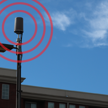
Small cell hardware installed on a utility pole.
Get Started
We hope this article has provided some value to you! If you ever need additional help, don't hesitate to reach out to our team. Contact us today!