This article may reference legacy company names: Continental Mapping, GISinc, or TSG Solutions. These three companies merged in January 2021 to form a new geospatial leader [Axim Geospatial].
The fifth-generation wireless telecommunications technology known as 5G is coming, and it’s going to impact more than just your cell phone. 5G will serve as the data transmission backbone that will enable autonomous vehicles, smart cities, and the internet of things (IoT).
From a technical and infrastructure standpoint, 5G is considerably different from the 4G LTE network in use now. The rollout of 5G is a massive undertaking with significant challenges. Geospatial technology can facilitate and solve some of the most vexing issues. In this blog series, we will examine these challenges and the solutions the geospatial industry can provide.
First, let’s explore what 5G is and how it works so we can better understand the rollout challenges ahead.
5G is a wireless technology standard that promises to deliver significant improvements in the capacity and speed of data transmissions often referred to as low latency. The primary driver behind its implementation is IoT interconnectivity where millions of devices, sensors, infrastructure – and even autonomous vehicles – can communicate. This split-second flow of densely packed data will enable intelligent systems to make better-informed decisions in daily operations of smart communities.
The 4G wireless network can’t handle this low-latency data throughput, but 5G can because it will operate in a vastly broader bandwidth of the radio-frequency (RF) spectrum with a much higher frequency. A technical hurdle for 5G is that RF signals in this spectrum are very short, and do not travel as far, which limits them to nearly line-of-sight usage. This means that cellular networks must be reconfigured into much smaller, tighter cell sites, placing many more access points called small cells.

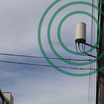
A small cell access point in an urban setting.
The engineering of these small cell networks is the first 5G challenge where geospatial technology can have an immediate positive impact. The design and construction will involve placing numerous access points and laying tens of thousands of miles of new fiber, both requiring detailed and up-to-date land cover and land-use maps for installation areas.
Network designers need accurate maps that display terrain and infrastructure for wave propagation modeling to determine where these towers can be built to effectively relay high-frequency signals. In rural regions, antennas mounted to towers will relay signals, but in more developed areas, such as urban and suburban zones, they will be attached to buildings and other structures. The increased number of small cell sites will mean more care will be taken to disguise them into the urban landscape.
Similar mapping is needed for placement of fiber. Fiber cable is often buried along existing transportation corridors, but much is hung on existing utility poles. Up-to-date maps derived from aerial and ground-based sensors inform designers of pole locations and determine where fiber cables can be buried, taking into account the most cost-effective routes, right of way, and land ownership details.
Having accurate geospatial data makes 5G network design easier and faster. In the next blog, we will examine more specifically how 3D geospatial data is utilized to fulfill the needs of small cell engineering.
Read more about the specifics of 5G here: https://www.sdxcentral.com/5g/definitions/what-is-5g/
Get Started
We hope this article has provided some value to you! If you ever need additional help, don't hesitate to reach out to our team. Contact us today!