This article may reference legacy company names: Continental Mapping, GISinc, or TSG Solutions. These three companies merged in January 2021 to form a new geospatial leader [Axim Geospatial].
Maps are everywhere. They come in countless varieties and are delivered in a plethora of formats and modalities including our smart phones, infotainment systems in our cars, and through the internet. Yet you can make a compelling argument that our geographic literacy has not improved due to a increased reliance on automated wayfinding and directions. Regardless, there’s no doubt that we continue to use maps a lot. In fact, Axim Geospatial is full of staff that were driven toward a career in surveying, mapping and geospatial technologies due to their interest in maps at a young age. Many of our employee profiles clearly attest to that as seen in many of our Employee Perspectives. In fact, my cocktail party response to the question “what do you do?” is often “I make maps”. Yet the reality is we all make them. We love data and we love visualization. We use a quick map in a report, we produce a map to hang on a wall to educate our staff, our clients, and our constituents or we take maps into the field to troubleshoot and solve crises or fight battles. There is clearly a utilitarian aspect to maps but when done well, there is also a beauty to them that draws you in. Yet it’s so easy to misuse data and generate maps that miss the mark as discussed in seminal books like Mark Monmonier’s ‘How to Lie with Maps’.
Cartography is the study and practice of making maps. We all make maps but cartography is the professional focus to refine the craft. It’s a blend of science, art and technology and as our Senior Cartographer Brian Goudreau likes to say “cartography is art with constraints”. Maps are a form of communication with an aspiration of providing an intense amount of information in a clear and concise manner that can support fast decision making. They document the current state of things and can illustrate patterns and dynamic changes in the landscape. They are an abstraction of reality and we simplify for scale. We portray data in a way that meets a need. To make a good map, the cartographer must understand the requirements of the end user, the ways in which they’re interact with that map, and the strengths and weaknesses of the source that is used to derive the map product. Some people like to think that if you “carry a GPS, you’re good”. Our national security and defense clients know that this is often not good enough given the plausibility of denied GPS. The fact is, printed maps will not go away. A bullet in a GPS receiver or smart phone renders it useless while a bullet through a map is a map with a hole in it.
Axim's core business is the creation of authoritative geospatial data that ultimately ends up in someone’s map. After all, the geospatial data we use in an application needs to come from somewhere, doesn’t it? As photogrammetrists, surveyors and mapping professionals so focused on data creation, there have been days when I wonder if the profession of cartography is still alive and well. The answer is unequivocally, yes.
Challenges We Face and Approaches to Resolving Them
Our cartographic specialists face numerous challenges to produce quality cartographic products. Below are five of the most common.
- Specifications and Procedures. To build a quality product you need a clear specification that dictates what to do and how to do it and procedures that document how to go about building a cartographic product in a repeatable and efficient way. Defining a specification is critical as it sets a baseline. But specifications can often be misinterpreted. Procedures ensure standardization amongst a team of individuals and support quality.
- Source Conditioning. Lots of source data is used to support a cartographic product and that source often comes from different custodians and is built at varying scales and time periods in support of different requirements. It's common to deal with a dozen different data sources when developing a map and the cartographer must often manipulate those datasets in some manner to prepare it for use. This "conditioning" is critical to prepare and package dataset inputs for cartographic production. Clear procedures and automation expedite conditioning and significantly improve efficiencies and the quality of the end product.
- Training. Employing a team to produce consistent cartographic products requires comprehensive training. Staff must understand what the product is and what the end user will be doing with the product. That knowledge informs the work. Training focuses on the procedures and processes defined and its relation to the overall specifications.
- Ancillary Product Creation. Cartographers often need to create ancillary products and merge them with conditioned source to generate a final cartographic product. Those ancillary products must be consistently built and stored to ensure repeatability. As an example, Axim's cartographic staff often generate spot elevations and hillshades from conditioned DEMs, and both geographic and Universal Transverse Mercator grids to help create the desired visualizations and end products.
- Names and Fonts. A good specification includes well thought through guidance on issues such as name and font usage. Roads often have several names (I-90 and the Kennedy Expressway in Chicago) and cities are referred to with different names (e.g., Peking vs Beijing, Mumbai rather than Bombay). Font selection is critical to ensure readability and support different uses and delivery mechanisms.
However, even good specifications don't always cover every issue. The cartographic team must stay in tune with changes and make game time decisions based on the cartographic product under development.
What Have We Built?
Axim produces a myriad of different cartographic products in support of national security and defense. Below are some examples.
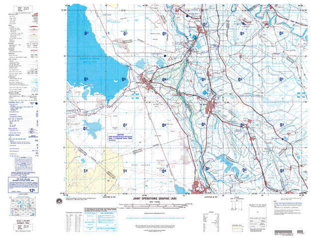
Joint Operations Graphics (JOGs).JOGs are 1:250,000 scale map products. They contain an intermediate amount of detail and typically cover and area 40 miles x 20 miles. JOGs are useful for all armed services given their general nature. They only cover land but offer a rich set of content from topography, airspaces, vertical obstructions to support safety of navigation, and utilities such as powerlines. The map content focuses on identifying horizontal control points and low altitude air navigation hazards. Ground units typically use this intermediate-scale product to complement the more detailed 1:50,000 Topographic Map (TM) products. One JOG is comprised of the generalized content of 24 contiguous TMs, making the JOG useful for mission planning. Axim cartographers are actively producing updated JOGs across five continents using the latest Department of Defense design.
Publicly available samples of JOGs are online at the University of Texas Library (here). One such example of from 1999 showing an area just south of Baghdad, Iraq is shown below.
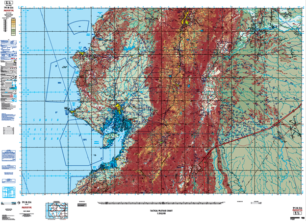
Tactical Pilot Charts (TPCs). TPCs are 1:500,000 scale map products for safety of navigation and support in plane navigation as well as planning. The goal of TPCs is seamless worldwide coverage. A specialized raster version of the TPC content known as CADRG is commonly used for digital display within the cockpit of all US Air Force airplanes. Given their safety of navigation focus, they are designed and printed in special ink for aeronautical and elevation features that are visible in low-light cockpit conditions. Axim produced the official Department of Defense TPC prototype in 2019 against a new design specification, and we are actively producing updated TPCs using this new design. That prototype is shown below.
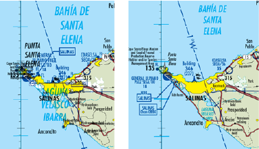
An example of the complicated cartographic production, particularly as it relates to sophisticated text place, required to produce this TPC is shown below in a before (left) and after (right).
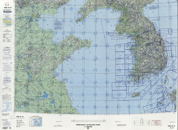
Operational Navigation Charts (ONC). ONCs are 1:1,000,000 scale map products. They are designed for medium-altitude flight navigation, including support for both radar and visual navigation. ONCs have not been updated by the Department of Defense recently, but Axim did produce the official Defense Department prototype ONC in 2019 against a brand-new design specification.
Declassified samples of ONCs are available at the University of Texas Library (here).One such example of from 1999 showing an area just south of Baghdad, Iraq is shown below.
Jet Navigation Charts (JNC). JNCs are 1:2,000,000 map scale products. These charts support high-altitude computer assisted radar navigation. Axim has produced JNCs as recently as 2019.
Global Navigation and Planning Charts(GNCs). GNCs are 1:5,000,000 map scale products. These charts support long-range, high speed, high altitude aerospace navigation. Basic landing options and radar navigation are included on the charts. Axim has produced GNCs as recently as 2019.
Get Started
Want to learn more about how we can support your cartography needs? Contact us today!