


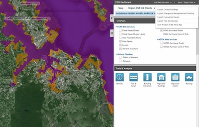
The Naval Facilities Engineering Command (NAVFAC) receives requests throughout the year concerning the impacts of flooding to Navy installations and assets. These questions typically revolve around the Federal Emergency Management Agency (FEMA) Flood Insurance Rate Maps (FIRMs), tidal surge due to hurricanes and storms, sea level rise impact, and flooding from large rainstorms. The inquiries come from various stakeholders and range from Naval facilities planning to recovery phases of flood impacts. In keeping with the GeoReadiness Program’s guiding principles of accelerating data sharing and innovation, the Navy team called upon Axim Geospatial to develop a solution called the Flood Inundation and Surge Hazard (FISH) tool. The primary goal of FISH was to empower Navy users to perform analysis of flood impacts on Navy assets in order to understand, mitigate, and respond to those challenges. Ultimately, NAVFAC wanted to save time and money by giving Navy users the ability themselves to perform analysis, assess impacts, and independently generate map products.
The Mid-Atlantic GeoReadiness Center (GRC) worked with Axim to gather requirements from stakeholders across the Enterprise. Axim then used that information to facilitate application planning, development and deployment. Through many hours of meetings with stakeholders and collaborative efforts with the client, our team was able to refine conversations into concise requirements. We then used our in-depth knowledge of Esri technology and the GeoReadiness Enterprise System (GES) to create a specification document and begin development. Based on this process and documents, Axim developed the application over the course of 6 months. The tool was built upon existing geospatial data and capability found within NAVFAC’s GeoReadiness Explorer (GRX) toolset thereby saving both time and money. Since its successful deployment, the application is now being more deeply integrated with the Navy Data Model (NDM), allowing the application to automatically integrate newer and more precise flood inundation and elevation data from NAVFAC, other federal civil agencies like the National Oceanic and Atmospheric Administration (NOAA), and other sources.
Now with FISH fully deployed, NAVFAC leadership have met their primary goal; giving stakeholders the ability to create their own analysis through the application and involve the local GeoReadiness Center should more detailed analysis be needed. Even more important, through FISH the Navy and its stakeholders gain a deeper understanding of flooding, its threats, and potential mitigation, to more effectively and efficiently protect Navy assets. We’re grateful for our partnership supporting NAFVAC and are humbled to be part of such an important mission.

