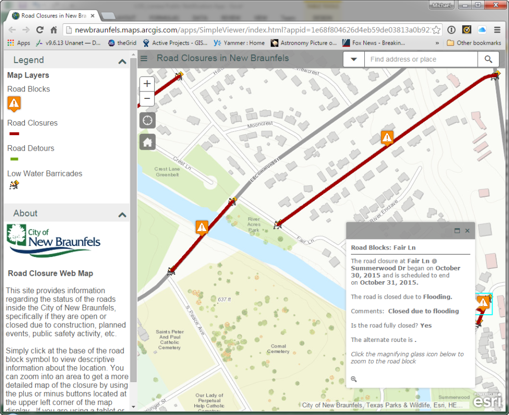
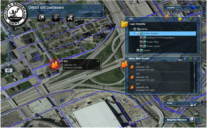
Axim Geospatial is now an NV5 company!

Learn More

Case Studies

    How the City of Hastings Transitioned to ArcGIS Utility Network Despite COVID-19 Restrictions, Limited Resources, & More

    How the City of Hastings Transitioned to ArcGIS Utility Network Despite COVID-19 Restrictions, Limited Resources, & More

    Emerson Chew | 2022

    The City of Hastings ran into some challenges along the way that threatened their transition to the ArcGIS Utility Network. Here is how they overcame them.

    Read More
    How Roanoke County, VA Optimized Efficiency Using Cityworks

    How Roanoke County, VA Optimized Efficiency Using Cityworks

    Thomas Wilson | 2021

    Find out how Cityworks helped the Community Development Department at Roanoke County improve user experience, maximize efficiency, and achieve their mission.

    Read More
    How Cityworks Propelled The City of Carmel’s Data to the Modern Era

    How Cityworks Propelled The City of Carmel’s Data to the Modern Era

    Thomas Wilson | 2021

    To transfer decades of permitting data into Cityworks PLL, the City of Carmel followed this 4-step process that ensured nothing fell through the cracks.

    Read More
    Waste Services Company in Canada Stays Up to Date with ArcGIS

    Waste Services Company in Canada Stays Up to Date with ArcGIS

    Shannon Prather | 2020

    To stay on top of Esri's offerings and keep the ArcGIS platform at the core of its operations and workflows, GFL Environmental has partnered with [Axim Geospatial] for nearly a decade, taking advantage of many of its premier GIS services.

    Read More
    City of Austin - Austin Water Uses SSP Sync for the Transition Planning and Implementation to Esri’s ArcGIS Utility Network

    City of Austin - Austin Water Uses SSP Sync for the Transition Planning and Implementation to Esri’s ArcGIS Utility Network

    Charidy Paige | 2020

    [Axim Geospatial] was selected to assess the organization’s readiness, redesign its geospatial data model, develop an implementation roadmap, and support initial implementation efforts for their migration.

    Read More
    Honolulu Department of Environmental Services Chooses ArcGIS Utility Network Readiness Assessment to Plan Migration

    Honolulu Department of Environmental Services Chooses ArcGIS Utility Network Readiness Assessment to Plan Migration

    Charidy Paige | 2020

    Honolulu ENV worked with [Axim Geospatial] to determine how to migrate to ArcGIS Utility Network.

    Read More
    Making it Easy to do Business with Roanoke County – An ArcGIS Site Selector and Open Data Portal Success Story

    Making it Easy to do Business with Roanoke County – An ArcGIS Site Selector and Open Data Portal Success Story

    Kevin Stewart | 2018

    Roanoke County, Virginia has been an early and steady adopter of many of the Esri suite of ArcGIS Solutions for Local Government to help construct an enhanced user experience for employees and citizens alike.

    Read More
    Opelika Utilities - Dead Meter Solutions, Powered by Insights for ArcGIS

    Opelika Utilities - Dead Meter Solutions, Powered by Insights for ArcGIS

    Kevin Stewart | 2018

    Opelika Utilities - Dead Meter Solutions, Powered by Insights for ArcGIS

    Read More
    Great Lakes Water Authority Uses Amazon Web Services Simple Storage Service for Disaster Recovery

    Great Lakes Water Authority Uses Amazon Web Services Simple Storage Service for Disaster Recovery

    Kevin Stewart | 2017

    Great Lakes Water Authority Uses Amazon Web Services Simple Storage Service for Disaster Recovery

    Read More
    Springfield, IL Approaches Snow Control Using Cityworks

    Springfield, IL Approaches Snow Control Using Cityworks

    Kevin Stewart | 2017

    Springfield, IL Approaches Snow Control Using Cityworks

    Read More
    Road Closures Application

    Road Closures Application

    Kevin Stewart | 2016

    Road Closures Application

    Read More

    Environmental Data Model Support

    Kevin Stewart | 2015

    Environmental Data Model Support

    Read More
    CDC Heart and Stroke Atlas

    CDC Heart and Stroke Atlas

    Kevin Stewart | 2015

    CDC Heart and Stroke Atlas

    Read More
    Master Data Management at Williams - Data Hierarchy Project

    Master Data Management at Williams - Data Hierarchy Project

    Kevin Stewart | 2015

    Master Data Management at Williams - Data Hierarchy Project

    Read More
    The City of Aurora Platform Alignment and Upgrade

    The City of Aurora Platform Alignment and Upgrade

    Kevin Stewart | 2014

    The City of Aurora Platform Alignment and Upgrade

    Read More
    Cityworks for Oakland County, MI

    Cityworks for Oakland County, MI

    Kevin Stewart | 2013

    [Axim Geospatial] has been providing staff augmentation services to the County of Oakland, MI since 2008. This ongoing relationship started with a single onsite resource to manage a data conversion project.

    Read More
    Web Based GIS Operation Dashboard

    Web Based GIS Operation Dashboard

    Kevin Stewart | 2013

    Web Based GIS Operation Dashboard

    Read More
    Arlington National Cemetery Operations Solution

    Arlington National Cemetery Operations Solution

    Kevin Stewart | 2013

    Arlington National Cemetery Operations Solution

    Read More
    Arlington National Cemetery Visitor Solution

    Arlington National Cemetery Visitor Solution

    Kevin Stewart | 2013

    We developed a custom, public-facing applications for use by the general public in locating grave sites, events, and points of interest. The public applications include a Flex-based web map viewer and

    Read More
    SCADA Integration for Gas Utility Company

    SCADA Integration for Gas Utility Company

    Kevin Stewart | 2013

    The utility company had a SCADA system that it used to manage the infrastructure. What they needed was a web based system to view this information and that is what we delivered.

    Read More