


This article was written regarding work conducted under legacy company names: Continental Mapping, GISinc, or TSG Solutions. These three companies merged in January 2021 to form a new geospatial leader Axim Geospatial.
Overview
Axim Geospatial is supporting renewable energy developers on multiple utility-scale solar projects in Texas with high accuracy mapping for site characterization, planning, engineering, and system design totaling a generation capacity of up to 900-megawatts of renewable energy.
 The increase of renewable energy generation is evident throughout the United States. Towering wind-driven turbines dot the country’s landscape in both expansive and localized installations. Solar farms are methodically constructed for maximum efficiency, with long rows of panels spanning large acreages across the nation. Power generation and transmission are critical infrastructures that requires detailed planning and exacting engineering, which is exceedingly true for renewable energy. The footprints of solar and wind renewable energy generation sites are more expansive than other types.
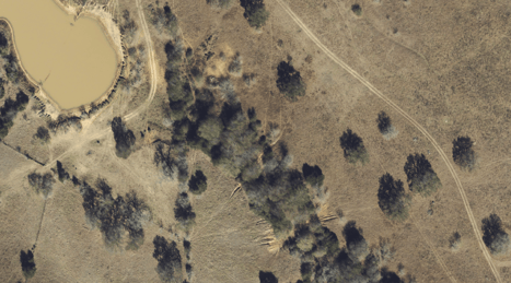
Pre-construction digital aerial imagery shows in high-resolution current site conditions.
Texas is a prime location for solar farm development, with large expanses of rural and arable land, favorable weather for solar power generation, and sprawling urban and industrial areas with large energy demands. Another contributing factor across the nation is an increase in interest in renewable, domestically produced energy. Renewable energy developers and engineering, procurement, and construction (EPC) firms have partnered with Axim on recent utility-scale solar projects in Texas for geospatial data insight to improve site assessment and enhance system design, while also de-risk and accelerating construction. Across multiple sites, these renewable energy installations spanned more than 7000 acres. At full generation capacity, these sites would produce a significant amount of energy, up to 900 megawatts. Axim has considerable experience supporting the power generation and transmission markets and brings a myriad of geospatial solutions to bear.
The large footprint of solar generation sites still requires precise data to support engineering and design. To accomplish data collection across such large areas, Axim] deployed fixed-wing aircraft with high accuracy lidar and imagery sensors. Additional ground-based survey crews captured data and control points to ensure accuracy and quality control
“Axim Geospatial turned around raw data from field to actionable geo-data insight in 20 days.”
Axim utilizes the best-fit mapping technology – from sensors to tools to processing and distribution software – to ensure client requirements are met. Combined with experienced project managers, field staff, and analysts, the resulting mapping products inform the site characterization both in a geospatial context and feasibility of design and serve to improve client outcomes in a number of ways.
 Traditional survey methods covering such large areas require weeks of costly survey crew field time. Using aircraft-mounted sensors, the data collection effort was measured in hours. Considerate of project timelines and to avoid cost overruns, Axim turned around raw data from the field to actionable geo-data insight in 20 days. The aerial lidar data were classified into the ground and non-ground points, which provided a source to create highly accurate elevation contours. Designers can import the elevation data, as well as the high-resolution aerial imagery to industry-standard software programs.
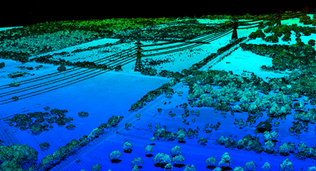
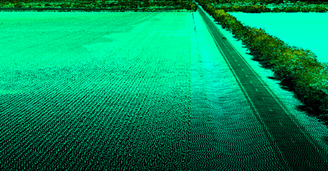
The infrastructure and arable land are captured in detail in highly accurate 3D lidar point clouds.
The mapping products enabled engineers and project members to understand in detail the variable topography of the site, the environmental context, and condition of existing infrastructure, capture measurements, identify potential challenges, and reduce risk with authoritative situational awareness.
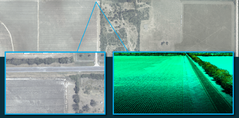 One area is shown in wide-area imagery, detailed imagery, and 3D lidar.

